
Reference Manual Owner manual


Survey Pro Reference Manual
R-204
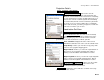
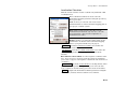
Use Geoid: is where you choose to use a geoid model with this zone.
When this box is checked, you can select a geoid model from the
dropdown list to use with the coordinate system. When this box is
unchecked, no geoid will be used with the coordinate system. You can
pick a geoid model from the database using the drop down box.
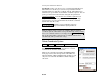
Pick from Database : opens the Select Coordinate System screen
(Page R-204) where you can pick a reference stereographic map
projection zone or a solved localization site from the coordinate
system data base file (.csd).
Reset Projection : initializes a new localization reference
stereographic map projection with the input parameters.
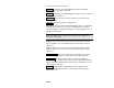
Note: To simply assign a geoid to use with the TDS Localization
coordinate system, which will be set up automatically with your first
base, leave all fields of this screen empty and tap Reset Projection .
The geoid setting will be applied to the coordinate system setup
automatically with your first base setup.
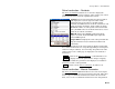
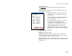
Select Coordinate System
Survey Projection Reset Origin… Pick from Database.
The Select Coordinate System screen is used to pick a
Ground – TDS Localization mode default zone or solved
localization site from the database file.
This screen is described in detail in the Mapping Plane
mode projection section on Page R-215. The difference
when in Ground – TDS Localization mode is that you can
only select records from the TDS Localization Region
collection.