
Reference Manual Owner manual


Survey Menu – GPS Module
R-203
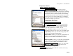
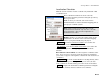
Projection Details
Survey Projection Show Details….
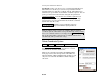
Save System To Database : will save the current
projection record to a coordinate system database file.
First, the current database file is checked for a matching
record, and if found you will be prompted that you need
not save the current coordinate system. If no matching
record is found, then the current coordinate system will
be saved as a new record. If a different record with the
same name is found, you will be prompted to rename the
current record before you can save.
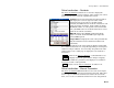
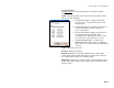
Localization Set Zone
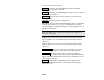
Survey Projection Reset Origin….
The Localization Set Zone screen is used to manually
configure the parameters of the localization reference
stereographic projection. It is also used to select the
geoid model to use with localization coordinate systems.
Zone / Site Name: displays the name of the current
initialized localization zone or the solved localization site.
Setup Group: is where you enter the set up group of the
reference stereographic mapping plane.
Origin Latitude: is where you enter the origin latitude of
the reference stereographic mapping plane. This is
usually set at the latitude of the first base location.
Origin Longitude: is where you enter the origin longitude
of the reference stereographic mapping plane. This is
usually set at the longitude of the first base location.
Origin Height / Origin Scale : is where you enter either
the height or the scale factor used to reference the
localization system to ground level.
Same as Base : updates the values with the coordinate and set up
group of the GPS base station.