
Reference Manual Owner manual

Survey Menu – GPS Module
R-193
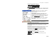
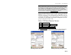
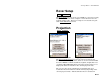
Check Control Point Screen
Survey Control Points Check Point. or
Data Collection Control Check Point.
The Check Control Point screen is used to check a control point. This
is done when you want to verify the quality of the coordinate system
solution.
Coordinates: displays the local coordinates computed
using the cu5rrent measurement and the latest
projection solution.
Solution Quality: displays the quality of the current
measurement: the solution type, the number of
satellites used, and the horizontal and vertical precision
computed by the receiver. These values are explained
with the GPS Status screen
(Page R-168)
Errors: displays the differences between the computed
local coordinates and the known coordinates for the
control point.
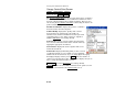
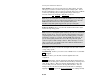
Note: If the Errors are larger than the measurement
precision of the instrument, you probably have a
problem with your projection solution.
Session Time: displays the total occupation time so far for this
measurement.
Count Status: displays Measuring when you have current coordinates
from the receiver and the screen is updating with the latest
measurement. If you are using Epoch Averaging, Averaging is
displayed after you tap Accept while the number of epochs is
averaged in Survey Pro. Suspended is displayed if you are not
receiving valid data from the receiver.
GPS Status : opens the GPS Status screen (Page R-168).
Accept : writes the results to raw data and returns you to the
Control Points screen.