
Reference Manual Owner manual


Survey Pro Reference Manual
R-192
Control Points
Survey Control Points. or
Data Collection Control
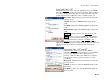
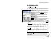
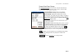
The Control Points screen is used to measure GPS control points to
use in the localization adjustment, or to check the location of exiting
points against GPS measurements and the latest coordinate system.
GPS Status: displays the current solution type, radio
signal quality, number of satellites used, and the
receiver’s estimate of the horizontal precision of the
current point. If this area is tapped, the GPS Status
screen will open (Page R-168).
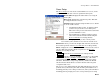
Set HR : displays the current antenna measurement
and measure to setting. You can change the antenna
measurement by entering a new value in the edit box.
This new antenna height will be sent to the receiver with
your next control or check point collection. You can
change both the antenna measurement and measure to
setting by tapping on Set HR to open the Receiver
Antenna screen (Page R-181).
Projection : opens the Projection screen (Page R-200).
View Points : opens the View Coordinates File screen, where the
project points can be examined.
Post Process : opens the Receiver Session screen (Page R-197), where
you can occupy a point for a post processing only session. This allows
you log a session in the post processing file using an existing point
name without changing that point record in the job file.
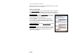
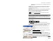
Check : opens the Check Control Point screen, where the local
coordinate computed from the measurement is compared to the local
coordinate’s known value.
Control : opens the Occupy Control Point screen, where geodetic
coordinates are measured at a point with local coordinates and added
to that point record in the job file.