
Reference Manual Owner manual


Survey Pro Reference Manual
R-164
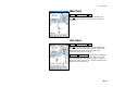
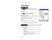
Foresight Card
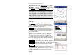
Survey Remote Control Results.
The Foresight card is available only if the backsight is
solved. It displays live coordinates for the current
foresight.
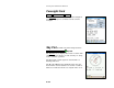
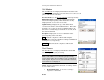
Sky Plot
(available only when using GeoLock)
Survey Remote Control Sky Plot
The Sky Plot screen displays the relative location of the
visible satellites in the sky, as well as if they are being
used to calculate a position.
Satellites with a usable signal are shown with red
flashing indicators.
The Elevation Mask is the minimum angle above the
horizon where locked satellites are used for a solution.
This area is indicated on the screen by the inner circle.