
Reference Manual Owner manual


Survey Menu
R-163
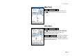
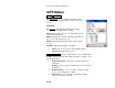
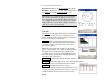
Map Card
Survey Remote Control Map.
The Map card displays a live map showing the total
station position relative to the current foresight and
backsight.
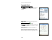
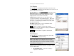
Aim Card
Survey Remote Control Aim.
The Aim card is used to precisely aim the instrument.
Tapping around the total station graphic will turn the
instrument to the location corresponding to the
horizontal and vertical scale bars.
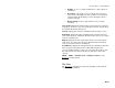
By Angle / By Distance : toggles between turning by
angles or by distances, respectively. The scales in the
scale bars will also switch between angles or distances.
The scales in the scale bars are calculated using the last
distance that was measured.