
Reference Manual Instruction Manual


561
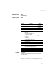
Query Command Library
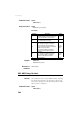
Example $PASHQ,GMP
$GPGMP,131745.00,LOC,,45215.125,14587.298,R,11,1.5,125.221,5.214,1.5,
454*xx
See also $PASHS,NME
s2
Map projection identification
RTCM3.1 - message 1024:
• LOC: Local coordinate system
RTCM3.1 - message 1025, 1026 or 1027:
• TM: Transverse Mercator
• TMS: Transverse Mercator (West orien-
tated)
• LCC1SP: Lambert Conic Conformal (1SP)
• LCC2SP: Lambert Conic Conformal (2SP)
• LCCW: Lambert Conic Conformal (West ori-
entated)
• CS: Cassini-Soldner
• OM: Oblique Mercator
• OS: Oblique Stereographic
• MC: Mercator
• PS: Polar Stereographic
• DS: Double Stereographic
LOC, TM, TMS,
LCC1SP,
LCC2SP, LCCW,
CS, OM, OS,
MC, PS, DS
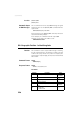
s3
Map zone
(RTCM3.1: empty)
f4
X (Northern) component of grid (or local) coor-
dinate, in meters
±999999999.999
f5
Y (Eastern) component of grid (or local) coor-
dinate, in meters
±999999999.999
s6
Mode indicator:
• N: No fix
• A: Autonomous
• D: Differential
•R: Fixed RTK
• F: Float RTK
N, A, D, R, F
d7
Number of GNSS Satellites being used in the
position computation
3-26
f8 HDOP 0-99.9
f9
Altitude above mean seal level, or local alti-
tude, in meters.
± 99999.999,M
f10 Geoidal separation in meters. ± 999.999,M
f11 Age of differential corrections, in seconds 0-999.9
d12 Base station ID 0-4095
*cc Checksum *00-*FF
Parameter Description Range