
Reference Manual Instruction Manual


557
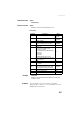
Query Command Library
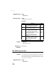
Command Format Syntax
$PASHQ,GGA[*cc]
Response Format Syntax
$GPGGA,m1,m2,c3,m4,c5,d6,d7,f8,f9,M,f10,M,f11,d12*cc
Parameters
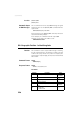
Example $PASHQ,GGA
$GPGGA,131745.00,4717.960847,N,00130.499476,W,4,10,0.8,35.655,M,
47.290,M,3.0,1000*61
Comment The code allotted to a position solution of the SBAS
differential type is either “2” or “9”, depending on the last
$PASHS,NPT command run.
Parameter Description Range
m1 Current UTC time of position (hhmmss.ss)
000000.00-
235959.99
m2 Latitude of position (ddmm.mmmmmm)
0-90
0-59.999999
c3 Direction of latitude N, S
m4 Longitude of position (dddmm.mmmmmm)
0-180
0-59.999999
c5 Direction of longitude E,W
d6
Position type:
• 0: Position not available or invalid
• 1: Autonomous position
• 2: RTCM Differential (or SBAS Differential)
•3: Not used
• 4: RTK fixed
• 5: RTK float
• 9: SBAS Differential. See comment.
0-5, 9
d7
Number of GNSS Satellites being used in the
position computation
3-26
f8 HDOP 0-99.9
f9,M
Altitude, in meters, above mean seal level.
“M” for meters
± 99999.999,M
f10,M
Geoidal separation in meters. “M” for meters.
Based on the official NATO's standard mean-
sea-level algorithm (5-degree grid of height).
± 999.999,M
f11 Age of differential corrections, in seconds 0-999
d12 Base station ID (RTCM only) 0-4095
*cc Checksum *00-*FF