
Instruction Manual

English
4
1. Real coordinates of points A (x1, y1) and B (x2, y2), and
horizontal distance (D) between points A and B. Points A
and B are arbitrary points well distributed horizontally on
the image file and easy to spot both on the image file
(map) and in the field.
2. Real coordinates of point O (x0, y0) located at the upper-
left corner of the image file.
3. Image width expressed in pixels.
Determining Points A & B and Distance D
• Choose two points that can easily be spotted both on the
image file and in the field.
• Go the the field and survey these two points with your
surveying system. This immediately gives the coordinates
x1, y1 and x2, y2 of points A and B respectively.
• From these coordinates, you can deduce D:
D = | x2-x1 |
Determining the Coordinates (x0, y0) of Point O
• Print out the image file using a high-quality printer.
• Using a graduated ruler, measure successively the lengths
of D, dh and dv on the map printout.
• Assuming the obtained measurements are respectively D’,
dh’ and dv’, we have:
D / D’ = dh /dh’ = dv / dv’
This means the values of dv and dh can be determined as
follows (make sure you use the same distance unit for all
these distances):
dh = (D x dh’) / D’ and dv = (D x dv’) / D’
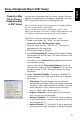
A (x1, y1)
O (x0, y0)
B (x2, y2)
W
D
dv
dh