
Operation Manual

Explanation of functions
Function Explanation Step
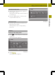
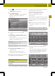
Display typeDisplay type
Options for different
displaysduring route
guidance
X
Press Display typeDisplay type.
X
Select Map onlyMap only, Turn IconsTurn Icons or
Compass
Compass.
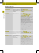
Map viewMap view
Options for different
map orientations
X
Press Map viewMap view.
X
Select Align map to northAlign map to north,
Align map automaticallyAlign map automatically,
Dynamic mapDynamic map or 3D map3D map.
North up: the map is displayed so that
north is at the top, the point of the
north arrow always points up.
Map in driving direction: the map is
displayed so that the heading is
always up. The north arrow turns. The
point of the current vehicle position
always points up.
Dynamic map: when asmallermap
scale is used (e.g. when drivingonthe
freeway), the map is displayed so that
north is alwaysupinorder to make
orientation easier.
3D map: the map is shown from the
bird's-eyeview.
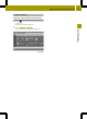
Auto zoomAuto zoom (Expert
mode)
Selects how much amap
section will be zoomed
in before achangein
direction.
X
Press Auto zoomAuto zoom.
X
Select NearbyNearby, MediumMedium or FarFar.
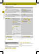
Map colorsMap colors (Expert
mode)
Sets the display to day
or night display or
switches
automatically.
X
Press Map colorsMap colors.
X
Press AutomaticAutomatic, Day designDay design or
Night designNight design in the list.
Automatic: the display design
changes dependingonthe brightness
determined by the lightsensor.
Day design: the displayisalwaysset
to day design.
Night design: the displayisalways
set to nightdesign.
54
Map operation and settings
>> Navigation.