
Operation Manual

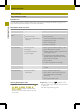

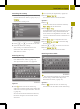

The map shows:
R
the destination address (at the top)
R
the route as ablue line
R
the selected route option (e.g.
standard) with the distance and
estimated journey duration to the
destination
Map after route calculation (Expert mode)
:
Address entered
;
Route calculated (light blue)
=
Selected route option
Selection Function
DestinationDestination
informationinformation
Calls up the detailed
information menu.
X
Store the city as a
favorite or as the
home address
(Y page 36).
X
Check/change the
route options
(Y page 37).
CalculateCalculate
alternativesalternatives
(Expert mode)
Calculates two
additional
alternative routes.
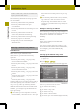
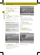
Calculating alternative routes
Audio system navigation/multimedia
calculates two alternative routes in Expert
mode (e.g. short, fast).
X
Press Calculate alternatives
Calculate alternatives.
The alternative routes are calculated.
After the alternative routes have been
calculated, you will hear Route
Route
calculation completedcalculation completed.
The map shows the following routes on the
right:
R
standard (light blue)
R
alternative 1(green)
R
alternative 2(light brown)
Each route is shown with the distance and
estimated journey time to the
destination.
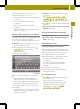
X
To view information about route/
alternative route ==: press ã.
You see the following information:
R
length (distance)
R
journey time (estimated)
R
arrival time (estimated)
R
highways (length of the route used)
R
toll roads (length of the route used)
R
ferries (length of the route used)
X
Press & to close the display.
i
The ã symbol is shown in red if aroute
option (e.g. Avoid ferriesAvoid ferries)that has
been selected for the route does not make
sense. Set the route options (Y page 33).
X
To hide the alternative routes: press
Hide alternativesHide alternatives.
X
To start route guidance: press OK
OK.
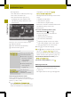
Entering aZIP code
X
Pressthe entry with the zip code in the
"Entering anew destination" menu
(Y page 34).
The input menu for the zip code appears.
38
Destination input
>> Navigation.