
Data Sheet

6 / 16
Copyright (c) 2009-2013 RoboPeak Team
Copyright (c) 2013-2016 Shanghai Slamtec Co., Ltd.
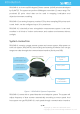
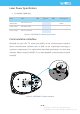
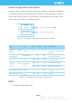
sampling data continuously. Host systems can configure output format and stop
RPLIDAR A1 by sending stop command. If you need detailed data format and
communication protocol, please contact with SLAMTEC.
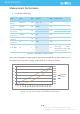
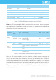
Figure 1-4 The RPLIDAR A1 Sample Point Data Information
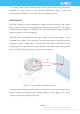
Figure 1-5 The RPLIDAR A1 Sample Point Data Frames
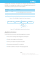
Application Scenarios
The RPLIDAR A1 can be used in the following application scenarios:
o Home service /cleaning robot navigation and localization
o General robot navigation and localization
o Smart toy’s localization and obstacle avoidance
o Environment scanning and 3D re-modeling
o General simultaneous localization and mapping (SLAM)
Data Type
Unit
Description
Distance
mm
Current measured distance value between the rotating
core of the RPLIDAR A1 and the sampling point
Heading
degree
Current heading angle of the measurement
Quality
level
Quality of the measurement
Start Flag
(Boolean)
Flag of a new scan
…
(d
ሾ
n − 1
ሿ
, θ
ሾ
n − 1
ሿ
)
(d
ሾ
n
ሿ
, θ
ሾ
n
ሿ
)
(d
ሾ
0
ሿ
, θ
ሾ
0
ሿ
)
(d
ሾ
1
ሿ
, θ
ሾ
1
ሿ
)
…
Start Flag
A new scan