
User's Manual

- 38 -
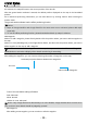
this moment, the map will locate to the current position of the aircraft.
After the ground station software is started, the default position displayed on the map is the last added
position.
As to undesired positioning information, you can also delete it by clicking “Delete” after selecting the
location name.
The ground station software has the ofine positioning function.
Notice:
1. Maps of Google Satellite and Google Earth for the same area are not universal; please add maps
separately.
2. To use the ofine positioning function, please download and back up maps in advance.
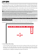
Add Waypoint
Method 1: Add a waypoint, please directly double-click the position where you want to add a waypoint on
the map.
Method 2: Click [Add Waypoint] in the Flight Mission Editor, and then click the position where you want to
add a waypoint on the map to add a waypoint.
It is better to add the first waypoint near home point to prevent the aircraft from colliding with
obstacles due to excessive obliquity of the aircraft route during its ascending.
Add all the desired waypoints with the same method.
After adding the waypoints, you can view the following information of waypoints on the map:
Horizontal projection distance between two waypoints
Air route
Index number of waypoint
Color of air route before editing is nished:
Red: Abnormal
White: Normal
Hidden air route: Abnormal
Notice: Only Google Earth hints abnormality in air route altitude; Google Satellite does not have such
hint, so the air route altitude should be judged by yourself.
Edit Waypoint
After adding a new waypoint, you can continue to edit the waypoint.