
User's Manual


Software Overview
ALPHA3D USER MANUAL | 2019-06 P a g e | 81
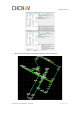
5.3 CoPre - Point Cloud Processing Software
5.3.1 CoPre Software Overview
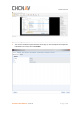
CoPre is a CHC designed one-button data pre-processing software enables both point cloud
processing and panorama image collation. It also supports lots of powerful functions such as
custom coordinate system, panorama stitching, point cloud colorized and depth image.
Meanwhile, it can download & browse real-time map and manually select area which more
interested from raw data based on GPS signal value, which is convenient and flexible for
realizing the solution of the original scanner data. The static data can be automatically filtered
during the solution process, and the data can be backed up multiple times and supported by
distance filtering, gray value filtering and skip noise filtering.
5.3.2 CoPre Quick Guide
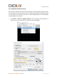
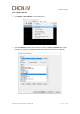
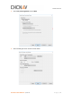
5.3.2.1 Import Project
◼ Click New to import data project folder which start with “@@” and click Select Folder: