
User's Manual
Page2
1.6. USEANDCARE
The P3E Sensor is designed to withstand the rough environment that
typically occurs in the field. However, the P3E Sensor is high‐precision
electronicequipmentandshouldbetreatedwithreasonablecare.
2. O
VERVIEW
2.1. F
EATURES
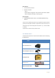
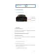
Designed for seamless integration, the P3E is a powerful
multi‐application GNSS Receive or which delivers state‐of‐
the‐artpositioning features in a rugged enclosure. The CHC P3E GNSS
Receive provides a cost‐effective answer to demanding applications
such as geodetic reference station, academic research, precision
agriculture RTKnetwork,deformationmonitoring,centimeteraccuracy
RTK sensor for marine survey, dredging or any GPS/GNSS machine
guidancewhenhighperformancesandreliabilityarerequired.
The P3E offers outstanding performances with proven and innovative
220‐channels GNSS functionality. The future proof multi‐constellation
trackingfeatureincreasesavailabilityinobstructedskyconditionssuch
as construction sites in urban areas while securing RTK accuracy. The
very low noise GNSS carrier phase measurement and low level
elevation tracking technology make the P3E a powerful reference
stationsolution..
2.2. S
PECIFICATIONS
GNSScharacteristics
220channelswithsimultaneouslytrackedsatellitesignals
∙ GPS:L1C/A,L2E,L2C,L5
∙ GLONASS:L1C/A,L1P,L2C/A,L2P,L3
∙ BDS:B1,B2
∙ SBAS:WAAS,EGNOS,MSAS
∙ Galileo:L1BOC,E5A,E5B,E5Alt8OC
∙ QZSS:L1C/A,L1SAIF,L2C,L5
Advancedmultipathmitigationtechnology
Lownoisecarrierphasemeasurementwith<1mmprecisionina1
Hzbandwidth.
Performancespecifications
(1)
RealTimeKinematics(RTK)
∙ Horizontal:8mm+1ppmRMS