
User's Manual


Page
48
X360 GIS Reference
Receiver
User
Guide
–
SPECIFICATIONS
This chapter describes the specifications for the X360 GIS Receiver.
Specifications are subject to change without notice.
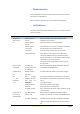
• GNSS CHARACTERISTICS
Feature
Specification
Tracking
–
220 channels
• GPS: L1 C/A, L2C, L2E, L5
–
Pseudo-range measurement with high-
precision
multi-correlator
–
Very low noise carrier phase measurements with <1
mm
precision in a 1 Hz bandwidth
Real Time Kinematic (RTK)
Horizontal: 8 mm + 1 ppm
RMS
Vertical: 15 mm + 1
ppm RMS
Post Processing Static
Horizontal: 2.5 mm + 0.5 ppm
RMS
Vertical: 5 mm + 0.5 ppm
RMS
Initialization time
Typically < 10 s
Initialization reliability
Typically > 99.9%
• COMMUNICATION
Feature
Specification
RJ45 Jack
Ethernet
DB9 male
3-wire RS232, see C.I. CHC X360 Receiver COM 1 (10-pin LEMO
port)
definition for details
COM1 (10-pin LEMO
port)
8-wire RS232, see C.II. CHC X360 Receiver COM 2 (10-pin LEMO
port)
definition for details
COM2 (10-pin LEMO
port)
9-wire RS232, see C.III. CHC X360 Receiver db9 male
connector
definition for details
USB port
Type-A USB receptacle, operates in Host mode
Bluetooth
Fully integrated, fully sealed 2.4 GHz Bluetooth wireless technology
Protocols
Correction formats: CMR, CMR+, SCMR, RTCM2.3,
3.0
Observables: RT17, RT27, RTCM3.X
Position/Status I/O: NMEA-0183 V2.30 (GPGGA & GPGSV)