
Use Manual
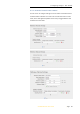
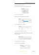
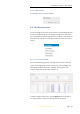
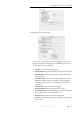
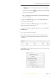
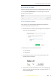
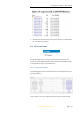
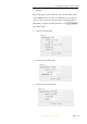
Table Of Contents
- INTRODUCTION
- GETTING STARTED WITH I70
- FRONT PANEL OPERATION
- BASE STATION SETUP AND OPERATION
- ROVER STATION SETUP AND OPERATION
- CONFIGURING THROUGH A WEB BROWSER
- POSITION SUBMENU
- ACTIVITY SUBMENU
- GOOGLE MAP SUBMENU
- TRACKING TABLE SUBMENU
- TRACKING INFO. TABLE SUBMENU
- TRACKING SKYPLOT SUBMENU
- SATELLITE ACTIVATION SUBMENU
- DESCRIPTION
- ANTENNA CONFIGURATION SUBMENU
- REFERENCE STATION SETTINGS SUBMENU
- RECEIVER RESET SUBMENU
- LANGUAGES SUBMENU
- USER MANAGEMENT SUBMENU
- USB FUNCTION SWITCH SUBMENU
- HCPPP SETTINGS SUBMENU
- 1PPS SUBMENU
- LOG SETTINGS SUBMENU
- FTP PUSH SETTINGS SUBMENU
- FTP PUSH LOG SUBMENU
- DATA DOWNLOAD SUBMENU
- IO SETTINGS SUBMENU
- DISCRIPTION SUBMENU
- MOBILE NETWORK SETTING SUBMENU
- EMAIL ALARM SUBMENU
- HTTP SUBMENU
- HTTPS SUBMENU
- FTP SERVICE SUBMENU
- DESCRIPTION SUBMENU
- WIFI SUBMENU
- BLUETOOTH SETTINGS SUBMENU
- RADIO SETTINGS SUBMENU
- BUZZER SETTING SUBMENU
- FIRMWARE INFO SUBMENU
- HARDWARE VERSION
- CONFIG FILE
- SYSTEM LOG DOWNLOAD SUBMENU
- USER LOG
- FIRMWARE UPDATE SUBMENU
- GNSS BOARD UPGRADE
- RADIO UPGRADE
- UPGRADE ONLINE
- GNSS REGISTRATION SUBMENU
- CLOUD SERVICE SETTING SUBMENU

7. Configuring through a web browser
i70 GNSS Receiver User Guide Page 41
For Reference Station Mode:
There are three modes available:
a) Auto Rover: The receiver will serve as a rover after this mode is
enabled, and then receive correction data through the working
mode set last time.
b) Auto Base: The receiver will serve as a base after this mode is
enabled, and then broadcast correction data based on coordinate
inputted by user, or obtained through autonomous positioning
automatically.
c) Manual Base: The receiver will serve neither as a base or a rover
after this mode is enabled. Users need to configure the receiver
manually.
For Reference Latitude and Reference Longitude:
There are mainly three methods to enter the reference coordinates and
shown as follows:
a) Acquire Current Position: Click this button to acquire current
position obtained through autonomous positioning automatically.
b) Manual Input: Manually input the coordinate of a control point.
c) From CORS: After the receiver logging in CORS, the software can
record the coordinate of current position based on fix solution.
For Sample for Average:
Users can determine the positioning limit and sampling amount. The
positioning limit falls into two types:
a) Single Solution Coordinates: Collect the coordinates of receiver
obtained through autonomous positioning.
b) Fixed Solution Coordinates: Only collect coordinates of receiver
with a fixed solution.
After the configuration of positioning limit and sampling amount, click
to carry out sampling and averaging → the progress bar will
show the progress → the result will be served as the coordinate of
current positon.
If users need to save the changes, please tap button.