
User's Manual


44
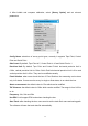
projection from Projection drop-down list. Coordinate Direction is North and East by
default. Users can adjust coordinate direction by selecting South Azimuth.
Finally, click [Finish
], and users have finished creating a new project. Return to the main
interface.
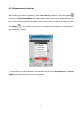
6.3 Confirm Coordinate Parameters
Open LandStar6.0, click [Project]→[CRS Params], select a required coordinate system
according to known points. Generally speaking, local coordinate system in China usually
uses Beijing-54 Ellipsoid. But all users need to do is to modify its central meridian (in
Standard Beijing-54 Ellipsoid, users must calculate 3 degree strap’s or 6 degree strap’s
central meridian according to known coordinates). users do not need to set [Transf], [Plane
Adjust] and [Height Adjust]. After point calibration, parameters will be saved automatically
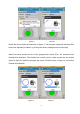
Ellips interface is shown in figure 1, including Name, a and 1/f. According to different areas,
select a corresponding ellipsoid from Name drop-down list. a and 1/f are default values and
there is no necessity to change them.
Projection interface and parameters of each model are shown in figure 2. Users can select