
User's Manual


38
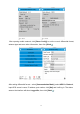
2. Ebubble Calibration
Select [Ebubble Option].( users had better carry out the operation outdoors and prepare a
level base. Centralize and level the base, set the instrument on the base. When the
instrument has searched satellites, the calibration result will be better. Besides, users had
better keep leveling in the calibration process.)
Figure 1 Figure 2
Ebubble: when clicking this button, there will be a prompt about offset
information(Figure 2). The tilt angle must be within 2 degrees or the calibration can not be
done. Then click [Yes], and Ebubble calibration starts. When the Ebubble is green in the
center, users have just finished Ebubble calibration.
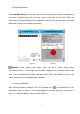
3. Compass Calibration
After finishing Ebubble Calibration, click the compass icon
in the bottom-left of the
interface(as shown in figure 3). Then select [Yes], an interface will pop up (as shown in
figure 4). ( users had better do the operation outdoors)