SHANGHAI ALLYNAV TECHNOLOGY CO., LTD R10 Operation Guide Shanghai AllyNav Technology Co.,Ltd Shanghai China GNSS Receiver Version 1.
SHANGHAI ALLYNAV TECHNOLOGY CO., LTD Content 1.R10 Specifications .....................................................................................................................3 1.1 Technical features ........................................................................................................ 3 1.2 Technical parametrest .................................................................................................4 1.3 Exterior dimensions ...............................................
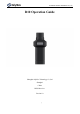
SHANGHAI ALLYNAV TECHNOLOGY CO., LTD 1. R10 Specifications R10 portable high-precision locator is a lightweight, simple and practical high precision GNSS RTK receiver, which is a low-cost solution for both portable and high-precision positioning.
SHANGHAI ALLYNAV TECHNOLOGY CO., LTD supporting more than 16 hours of continuous use. The total weight of the equipment is 0.55kg, small and light, easy to carry. Flexible in use, can be handheld or screwed directly onto the alignment bar for measurement. Software with standard version of measurement software or flagship version of measurement software with functions such as measurement, pointing and CAD placement.
SHANGHAI ALLYNAV TECHNOLOGY CO., LTD Data output Differential data: RTCM 3.3/3.2/3.1/3.0 Positioning data: NMEA-0183 Electrical parameters Endurance: ≥16h Input voltage: DC5V ≤1A Battery capacity: 4800mAh Power consumption:1w Physical Properties Operating temperature: -45℃~+75℃ Storage temperature: -55℃~+85℃ Physical size: Φ165mm*70mm Protection level: IP54 Impact and vibration: resistant to 2m drops Button: 1 button Indicator lights: 2 LED indicators Weight: 0.55kg Data interface.
SHANGHAI ALLYNAV TECHNOLOGY CO., LTD 1.
SHANGHAI ALLYNAV TECHNOLOGY CO., LTD 1.
SHANGHAI ALLYNAV TECHNOLOGY CO., LTD 2.
SHANGHAI ALLYNAV TECHNOLOGY CO., LTD 3. Software Description 3.1 Software profile AllyPad software is an engineering survey application software developed by Shanghai AllyNav Technology Co., Ltd. based on GNSS high-precision location application. The developers integrate based on years of surveying and mapping development and market experience accumulation, combined with the use habits of a large number of industry users and Android operation style habits.
SHANGHAI ALLYNAV TECHNOLOGY CO., LTD 3.2 Device connect At the main software interface, click [Device] on the corresponding function menu, as shown in Figure 3-1.The instrument includes Communication, Rover, Base, Static, Inspection accuracy, Device Setting, Restart Positioning, Device information and other functions. Figure 3-1 Click [Device] -> [Communication], as shown in Figure 3.1-1.
SHANGHAI ALLYNAV TECHNOLOGY CO., LTD 3. Communication mode includes Bluetooth Communication, TCP client Communication, etc. The way supported by each instrument manufacturer may be different. The basic Bluetooth mode is basically supported by all manufacturers. 4. Click on the equipment parameters, enter the Bluetooth search and selection, as shown in Figure 3.1-4, and click on the equipment to choose the equipment needed to connect.
SHANGHAI ALLYNAV TECHNOLOGY CO., LTD Figure 3.2-4 Figure 3.2-5 3.3 Point Survey Click [Survey] -> [Point Survey], as shown in Figure 3.3-1.The positioning of GNSS device output is measured and collected into the coordinate point library under certain precision limits.
SHANGHAI ALLYNAV TECHNOLOGY CO., LTD left side of the drawing area is the display of the function collection, these function menu can also display the required functions here according to the needs of the user to quickly operate some functions, the bottom right corner of the area shows the drawing scale, the icon above the scale is the trigger survey acquisition function button, the button can be moved according to the user's use habits, in a more convenient place to operate.
SHANGHAI ALLYNAV TECHNOLOGY CO., LTD some functions.These functions include: tilt survey switch, network map selection switch, drawing zoom in and reduce the whole map positioning center, screen point, CAD text annotation, length and area calculation, drawing background color setting, CAD layer setting, Coordinates Converter tools, Calculator tools and other functions, click the menu icon on the left to trigger the corresponding functions.
SHANGHAI ALLYNAV TECHNOLOGY CO., LTD Figure 3.3-7 Figure 3.3-8 3.4 Point Stakeout Click [Survey] -> [Point Stakeout] to enter the interface of the setting out point library, as shown in Figure 3.4-1. Point Stakeout refers to the location of the point at the field site if the point coordinates are known.
SHANGHAI ALLYNAV TECHNOLOGY CO., LTD setting, as shown in Fig. 3.4-3.The target can be set according to the southeast, northwest or left and right prompts, the reference direction of the front and back can be the front direction of the host or press the known reference point direction, and can also set the prompt range, setting out limit difference, etc.
Shanghai Allynav Technology Co.,Ltd. Figure 3.4-1 Figure 3.4-2 Figure 3.4-3 In the sample point to be released, click the data item, click the detailed information of the entry point, including the information of each setting point and the Figureical distribution map of the demout target and collection points, as shown in Figure 3.4-4, 3.4-5. Figure 3.4-4 Figure 3.
Shanghai Allynav Technology Co.,Ltd. FCC STATEMENT: This device complies with part 15 of the FCC Rules. Operation is subject to the following two conditions: (1) This device may not cause harmful interference, and (2) this device must accept any interference received, including interference that may cause undesired operation. Any Changes or modifications not expressly approved by the party responsible for compliance could void the user's authority to operate the equipment.