
Users Manual
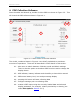
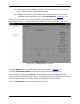
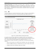
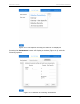
Table Of Contents

PDP User's Guide PDP Collection Software
21
4.1 Tools
Pressing the Tools button launches a window with four tabs (Figure 4-3). Each tab
is explained in detail below. It is important to confirm your settings before
collecting PDP data.
4.1.1 System Config
The System Config tab allows you to set collection parameters, as well as
configuring and enabling the GPS.
Collection Mode – this is the first, and most important, setting to consider as it
determines how you will collect data. This setting also controls the display of some
of the other options on the screen.
• Profile (shown in Figure 4-3) – this mode involves pushing the PDP over a
survey line or area and collecting a continuous profile of data. Typically, this
is done to investigate density changes over an area. In most cases, this is
done immediately after the asphalt has been laid, compacted and allowed to
cool. Multiple profiles can be collected and used to build a plan map, showing
density changes or other types of measurements over the survey area.
Profiles can be run in any direction, with the external GPS used for
positioning. Plan maps are created in the PDP Toolkit PC software.
Figure 4-3: The System Configuration screen showing Profile collection mode