
User's Manual


Noggin 13-Survey & Map Mode
81
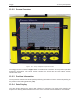
13.2.5.1 GPS Status
If a GPS receiver is attached to the DVL and enabled (13.3.5: p.112) a message will appear in
the bottom left corner of the menu indicating whether the GPS data is successfully being logged.
The possible messages are:
1) GPS: DGPS fix means differential GPS data are currently being logged.
2) GPS: GPS fix means standard GPS data are currently being logged.
3) GPS: fix not valid means GPS data are NOT currently being logged. This is usually
because GPS satellites are not available.
4) GPS: No Input means the GPS receiver is not operating properly. Check the settings
and test the system (13.3.5: p.112).
5) GPS: No GGA means the GPS receiver is not outputting a GGA NMEA string that
the DVL requires (13.3.5: p.112).
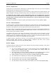
13.2.6 Total Distance Per Screen
The total distance that can be displayed on one screen varies depending on the Noggin system,
Station Interval (13.3.3.3: p.103) and Plot Interval (13.3.3.4: p.106). The DVL screen is 640
pixels wide.
As the Station Interval increases, the distance between data traces increases and the total
distance per screen increases.
As the Plot Interval increases, the total distance per screen decreases.
For more details on total distances and Station Intervals see 13.3.3.3: p.103.
To see how much data can be collected before the DVL memory is full and data must be deleted
or downloaded, see the DVL Recording Space (13.5.4: p.121).
Table 6:
Noggin
Normal
Plot
Interval
(pixels)
Normal
Station
Interval
(meters)
Total Data Distance
per Screen (meters)
Normal
Station
Interval
(inches)
Total Data
Distance per
Screen
(feet)
100 2 0.1 32 3.84 102.4
250 2 0.05 16 1.92 51.2
500 1 0.025 16 0.96 51.2
1000 1 0.01 6.4 0.48 25.6