
User's Manual

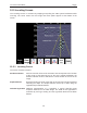


12-Locate & Mark Mode Noggin
60
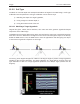
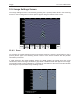
To determine the Soil Type using a Target Hyperbola:
1) With a target hyperbola visible on the image, back the GPR system up until the
Position Indicator is centered on the target hyperbola in the GPR image; preferably a
deep one with long tails because this provides the most accurate soil type calibration.
2) Use the Up and Down Arrows to move the Indicator Hyperbola shallower or deeper
in the GPR image respectively, until it lies overtop of the target hyperbola.
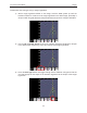
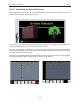
3) Press the Soil Type button and toggle through the five different soil types to find the
one that roughly fits the shape of the Indicator Hyperbola to the shape of the Target
Hyperbola.