
System Description

System Description and Installation Manual for MXS ICD10004-01
© Sagetech Corporation 2018 Confidential Proprietary Export-Controlled Page 92 of 160
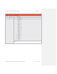
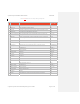
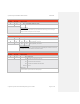
Estimated Latitude
Byte Offset Byte Name Field Description
36
LE0 LE0 LE1 LE2 Estimated Latitude
37
LE1 0x0F
0xF9
0xDF
0x1C
0x99
0x77
0x71
0x99
0x77
21.249983 Degrees
-9.000013 Degrees
-45.750010 Degrees
38
LE2
Estimated Latitude
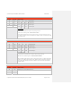
Latitude position is estimated when an Airborne Velocity message is received.
The data is sent in the following format: SMdddddd dddddddd dddddddd
The S bit indicates whether the data is positive or negative. If the S bit is set to “ONE” then the data is negative, if
set to “ZERO” then the data is positive. The M bit should be set to ZERO for Latitude. The resolution of the Latitude
field is 0.0000215 Degrees.
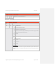
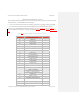
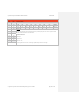
Estimated Longitude
Byte Offset Byte Name Field Description
39
GE0 GE0 GE1 GE2 Estimated Longitude
40
GE1 0x2B
0xA9
0x4C
0xC6
0x9C
0x90
0x79
0x7B
0x8B
61.558993 Degrees
-121.484177 Degrees
107.668998 Degrees
41
GE2
Estimated Longitude
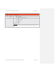
Longitude position is estimated when an Airborne Velocity message is received.
The data is sent in the following format: SMdddddd dddddddd dddddddd
The S bit indicates whether the data is positive or negative. If the S bit is set to “ONE” then the data is
negative, if set to “ZERO” then the data is positive. The M bit indicates a longitude of 180 degrees if
set to “ONE” and all remaining bits will be set to “ZERO”. The resolution of the Longitude field is
0.0000215 Degrees.
Estimated North/South Velocity
Byte Offset Byte Name Field Description
42
EN0 The MXS does not transmit Estimated Velocity .
43
EN1