
System Description

System Description and Installation Manual for MXS ICD10004-01
© Sagetech Corporation 2018 Confidential Proprietary Export-Controlled Page 45 of 160
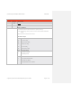
5. GPS Navigation Data Message: Type 0x04
The GPS Data Message:
Provides the MXS with GPS data, including - latitude, longitude, height, groundspeed, track, and validity,
accuracy and integrity measurements.
If used, should be sent at regular intervals (between one and five times per second), typically at the nominal
update rate of the GPS hardware.
Note: If the Navigation Receiver Valid bit (in the Hemisphere byte) is 0, then all data fields in the
message are required to be valid, except for Time of Fix (which can be set to all spaces if it is not
valid). If the Navigation Receiver Valid bit is 1, all data fields are considered invalid; sending the
message with the Navigation Receiver Valid bit set to 1 has the same effect as not sending the
message.
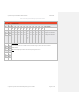
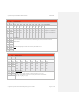
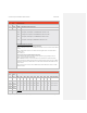
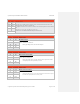
An overview of the GPS Navigation Data Message is shown in Table 0-13Table 6-13. Table 0-14Table 6-14 provides the
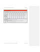
detailed message definition. An example of the GPS Navigation Data Message is found in Table 0-15Table 6-15.
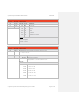
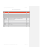
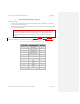
Table 0-13 GPS Navigation Data Message Payload Structure Overview
Payload Index Message Field Number bytes
00
GPS Longitude
11
11
GPS Latitude
10
21
Speed Over Ground
6
27
Ground Track
8
35
Hemisphere/Data Status
1
36
Time of Fix
10
46
Height
4
50
HPL
4
54
HFOM
4
58
VFOM
4
62
NAC
V
1