
System Description

System Description and Installation Manual for MXS ICD10004-01
© Sagetech Corporation 2018 Confidential Proprietary Export-Controlled Page 153 of 160
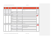
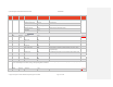
Step Message Msg
Direction
Field Name
18
Data Values (Hex) Data/Functional Description SDIM
Pressure Altitude [00 02 77] Pressure altitude is 631 feet
Checksum [D9]
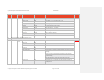
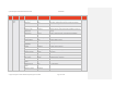
6
If specified by the installation message, construct and send GPS Navigation Data Message (Continue to construct and send GPS Data Message at 1-5 Hz )
GPS Data Sent from
host
Start Byte [AA] 13.56.3.5
Mess Type [04] Send GPS navigation data. This message must be sent periodically
(between 1 to 5 Hz) to maintain valid GPS data.
Mess ID [07]
Packet Len [3F]
GPS Longitude: [31 32 32 31 39 2E 37 35
30 30 32]
122.329167 Degrees West
GPS Latitude: [34 37 33 37 2E 32 32 34
30 30]
47.620400 Degrees North
Speed Over Ground: [31 32 35 2E 38 30] 125.80 knots
Ground Track: [30 37 37 2E 35 32 30 30] 77.5200 Degrees
Hemisphere [01] North and West Valid
Time of Fix: [31 32 33 37 32 32 2E 34
30 30]
37:22.4
Height [00 00 00 00] Not available
HPL [00 00 00 00] Valid
HFOM [00 00 00 00] Not available
VFOM [00 00 00 00] Not available