
System Description

SystemDescriptionandInstallationManualforRangeFinder ICD10000‐01
©SagetechCorporation2018ConfidentialProprietaryExportControlled Page74of130
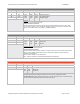
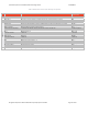
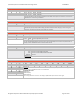
EstimatedLatitude
ByteOffset ByteName FieldDescription
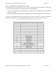
36 LE0 LE0 LE1 LE2 EstimatedLatitude
37 LE1 0x0F
0xF9
0xDF
0x1C
0x99
0x77
0x71
0x99
0x77
21.249983Degrees
‐9.000013Degrees
‐45.750010Degrees
38 LE2
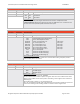
EstimatedLatitude
LatitudepositionisestimatedwhenanAirborneVelocitymessageisreceived.
Thedataissentinthefollowingformat:SMdddddddddddddddddddddd
TheSbitindicateswhetherthedataispositiveornegative.IftheSbitissetto“ONE”thenthedataisnegative,ifset
to“ZERO”then
thedataispositive.TheMbitshouldbesettoZEROforLatitude.TheresolutionoftheLatitudefield
is0.0000215D egr ees.
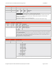
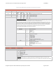
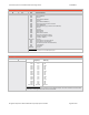
EstimatedLongitude
ByteOffset ByteName FieldDescription
39 GE0 GE0 GE1 GE2 EstimatedLongitude
40 GE1 0x2B
0xA9
0x4C
0xC6
0x9C
0x90
0x79
0x7B
0x8B
61.558993Degrees
‐121.484177Degrees
107.668998Degrees
41 GE2
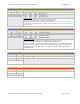
EstimatedLongitude
LongitudepositionisestimatedwhenanAirborneVelocitymessageisreceived.
Thedataissentinthefollowingformat:SMdddddddddddddddddddddd
TheSbitindicateswhetherthedataispositive ornegative.IftheSbitissetto“ONE”thenthedatais
negative,ifsetto“ZERO”thenthedataispositive.The Mbitindicatesalongitudeof180degreesif
setto“ONE”andallremainingbitswillbesetto“ZERO”.TheresolutionoftheLongitudefieldis
0.0000215Degrees.
EstimatedNorth/SouthVelocity
ByteOffset ByteName FieldDescription
42 EN0 EN0 EN1 EstimatedNorth/SouthVelocity
43 EN1 TheRangeFinderdoesnottransmitEstimatedVelocity.
EstimatedEast/WestVelocity
ByteOffset ByteName FieldDescription
44 EE0 TheRangeFinderdoesnottransmitEstimatedVelocity.
45 EE1