
System Description

SystemDescriptionandInstallationManualforRangeFinder ICD10000‐01
©SagetechCorporation2018ConfidentialProprietaryExportControlled Page71of130
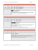
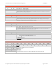
Longitude
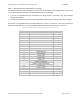
ByteOffset ByteName FieldDescription
18 EG0 EG0 EG1 EG2 Longitude
19 EG1 0xA0
0x80
0x04
0x00
0x28
0x25
0x80
0x60
0x09
‐134.997253Degrees
‐179.778214Degrees
5.828440Degrees
20 EG2
Longitude
Thedataissentinthefollowingformat:
SMdddddddddddddddddddddd
TheSbitindicateswhetherthedataispositive(East)ornegative(West).IftheSbitissetto“ONE”
thenthedataisnegative,ifsetto“ZERO”thenthedataispositive.TheresolutionoftheMbitis90
degrees.TheresolutionoftheLbitis180/2
23
(~0.0000215)degrees.
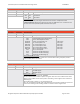
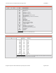
GeometricAltitude
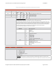
ByteOffset ByteName FieldDescription
21 GA0 GA0 GA1 GA2 GeometricAltitude
22 GA1 0x20
0x01
0xFF
0x00
0x28
0xC7
0x80
0x30
0xC0
32,770Feet
1,184.75Feet
‐225Feet
23 GA2
GeometricAltitude
Thedataissentinthefollowingformat:
Sddddddddddddddddddddddd
TheSbitindicateswhetherthedataispositiveornegative.IftheSbitissetto“ONE”thenthedatais
negative,ifsetto“ZERO”thenthedataispositive.Thegeometricaltitudeissentinfeetwitha
resolutionof0.015625feet.
Note:GeometricAltitudeisin2'scomplement.
Note::GeometricAltitudeistheWGS‐84GNSSHeightAbovetheEllipsoid.
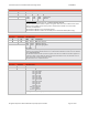
N/SVelocity
ByteOffset ByteName FieldDescription
24 NS0 NS0 NS1 North/SouthVelocity
25 NS1 0x00
0x08
0xFD
0xA7
0x25
0xEF
20.87Knots
260.63Knots
‐66.13Knots
North/SouthVelocity
FormattheN/SVelocityinthetarget’sStateVectorintoa16‐bit2’scomplementnumber
(SMdddddddddddddL,whereS=0fornorthand1forsouth,M=2048knots,andL=0.125knots),and
storetheresultintheN/SVelocityfieldoftheStateVectorreport.