
System Description

SystemDescriptionandInstallationManualforRangeFinder ICD10000‐01
©SagetechCorporation2018ConfidentialProprietaryExportControlled Page68of130
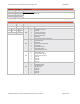
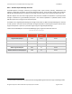
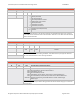
Table8‐48ADS‐BStateVectorReportMessagePayloadStructureDetail
ReportTypeandStructureID
ByteOffset ByteName FieldDescription
00 RS0
RS0(MSN) RS0
(LSN)
RS1 RS2 ReportTypeandStructureID
01 RS1
0x1 0xF
0xCF
0x98 StateVectorReportforAirborneTarget
OmittingGSandHDGonsurface,andestimatedvelocity.
02 RS2
0x1 0x7 0x32 0x18 StateVectorReportforSurfaceTarget
OmittingtheEstimatedPositionTimeOfApplicability,Geometric
Altitude,N/SandE/WVelocity,BarometricAltitude,Vertical
Rate,andEstimatedLat/LongandVelocity.
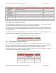
ReportTypeandStructureID
TheMostSignificantNibble(MSN)ofthebyteRS0containstheReportType.FortheStateVectorReport,thisfield
willalwayscontainavalueof0x1.ThisidentifiesthereportasaStateVectorReport.
TheremainingdataconstitutestheStructureID,whichindicatesthefieldsthatarebeingreportedinthecurrent
message.Ifthebitforthefieldissetto“ONE”,thenthedatafieldisavailableandincludedinthecurrentreport.If
thebitissetto“ZERO”,thisindicatesthatthefieldisnotreportedforthecurrentmessageandtheStateVector
messagewillnotincludethatfield.TheStateVectorMessagewillconcatenatethenextfieldtobeincludedintothe
report,followingthepreviousreportedfield.Thiswillbeperformedforeachdatafieldthatisreported.
ThebelowtableoutlinestheStructureIDlayout:
ByteName Bit StateVectorDataParameter(s)tobeReported
RSO(LSN) 3
2
1
0
TimeofApplicabilityforEstimatedPosition
PositionTimeofApplicability
VelocityTimeofApplicability
Latitude(WGS‐84)&Longitude(WGS‐84)
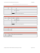
RS1 7
6
5
4
3
2
1
0
Altitude,Geometric(WGS‐84)
North/SouthVelocity&East/WestVelocity
GroundSpeedwhileontheSurface
HeadingWhileontheSurface
Altimeter,Barometric
VerticalRateGeometric/Baro.
NavigationIntegrityCategory
EstimatedLatitude
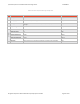
RS2 7
6
5
4
3
0‐2
EstimatedLongitude
EstimatedNorth/SouthVelocity
EstimatedEast/WestVelocity
SurveillanceStatus/Discretes
ReportMode
Reservedforfutureexpansion