
System Description

SystemDescriptionandInstallationManualforRangeFinder ICD10000‐01
©SagetechCorporation2018ConfidentialProprietaryExportControlled Page44of130
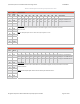
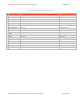
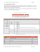
GPSHeight(WGS‐84)
ByteOffset ByteName FieldDescription
46 HT0 GPSHeight(WGS‐84)
Allzeros–AltitudenotavailableElse
FloatingpointHeight(meters)AboveWGS‐84ellipsoid
47 HT1
48 HT2
49 HT3
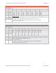
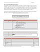
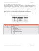
HorizontalProtectionLimit(HPL)
ByteOffset ByteName FieldDescription
50 HP0 HorizontalProtectionLimit(HPL)
Allzeros–HPLnotavailableElse
Floatingpointradius(meters)ofacirclecenteredonthetruepositionthatcontai ns
thecomputedpositionwithaprobability of10
‐7
/hour.
51 HP1
52 HP2
53 HP3
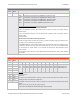
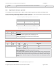
HorizontalFigureofMerit(HFOM)
ByteOffset ByteName FieldDescription
54 HM0
HorizontalFigureofMerit(HFOM)
Allzeros–HFOMnotavailableElse
Floating point radius (meters) of a circle in the horizontal plane and centered at the true
positionthatcontainsthecomputedpositionwithanaccuracyof95%
55 HM1
56 HM2
57 HM3
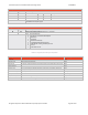
VerticalFigureofMerit(VFOM)
ByteOffset ByteName FieldDescription
58 VM0
VerticalFigureofMerit(VFOM)
Allzeros–VFOMnotavailableElse
Floatingpointdistance(meters)thatthecomputedaltitudecanbeaboveorbelowthetrue
positionwithanaccuracyof95%.
59 VM1
60 VM2
61 VM3
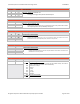
NavigationAccuracyforVelocity(NAC
v
)
ByteOffset ByteName FieldDescription
62 NAV0 MSN
Bits7‐4
0x0
0x1
0x2
0x3
0x4
0x5‐0xF
NAC
V
(MostSignificantNibble)
The field is used to declare the accuracy of own‐vehicle velocity. The value is
basedonGPSfigureofmeritforhorizontalvelocity.
Unknownor≥10m/s
<10m/s
<3m/s
<1m/s
<0.3m/s
Reserved
LSN
Bits3‐0
LeastSignificantNibble
Reserved