
User Guide Part 1

Wi-Fi Array
Viewing Status on the Wi-Fi Array 155
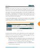
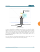
detailed information for the station by hovering over it. To enlarge all
rectangles, clear the Minimize All checkbox.
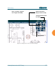
Figure 84. Minimizing stations
z
Scale: This view-only value shows the approximate distance represented
by each hashmark on the default map background. Scale is the rightmost
of the items displayed in the control area - you may need to scroll to the
right edge to see it.
z
Custom Image: Use this feature to replace the default background image
with your own image of the floor plan of your location. Click the Browse
button and browse to the desired file on your computer. This may be a
.gif, .jpg, .jpeg., .png, .htm, or .html file. The scale of the file should be 100
feet per inch. Then click Upload (see below). For more information on
using the custom, image, see “Working with the Custom Image” on
page 156.
z
Upload: After browsing to the desired custom image, click the Upload
button to install it. The map will be redisplayed with your new
background. No hash marks are added to the image display.
z
Reset: Click this button to restore the map display to the factory settings.
All attributes are restored—including the stations selected for display, the
scale, the rotation, and the background map.
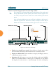
Normal station display
Minimized station display