
Overview of This Tutorial - Department of Geosciences

Tutorial: Hyperspectral Signatures and Spectral Resolution
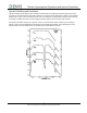
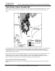
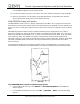
Case History: Cuprite, Nevada, USA
Cuprite has been used extensively as a test site for remote sensing instrument validation (Abrams et al., 1978;
Kahle and Goetz, 1983; Kruse et al., 1990; Hook et al., 1991). Refer to the following alteration map of the
region.
This tutorial illustrates the effects of spatial and spectral resolution on information extraction from multispectral
and hyperspectral data. You will use Landsat TM, GEOSCAN MkII, GER63, HyMap and AVIRIS images of
Cuprite, Nevada, USA, and you will see the effect of different spatial and spectral resolutions on mineralogic
mapping through remote sensing.
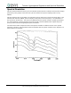
All of these data sets have been calibrated to reflectance. Only three of the numerous materials present at the
Cuprite site are used for comparison. Average kaolinite, alunite, and buddingtonite image spectra were
selected from known occurrences at Cuprite. Laboratory spectra from the USGS spectral library (Clark et al.,
1990) of the three selected minerals are provided for comparison to the image spectra.
Open and View USGS Library Spectra
Before attempting to start the program, ensure that ENVI is properly installed as described in the installation
manual.
5
ENVI Tutorial: Hyperspectral Signatures and Spectral Resolution