
Overview of This Tutorial - Department of Geosciences
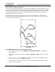

Tutorial: Hyperspectral Signatures and Spectral Resolution
21
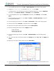
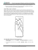
ENVI Tutorial: Hyperspectral Signatures and Spectral Resolution
Kruse, F. A., J. W. Boardman, A. B. Lefkoff, J. M. Young, K. S. Kierein-Young, T. D. Cocks, R. Jenssen, and P.
A. Cocks, 2000, HyMap: An Australian Hyperspectral Sensor Solving Global Problems - Results from USA
HyMap Data Acquisitions: in Proceedings of the 10th Australasian Remote Sensing and Photogrammetry
Conference, Adelaide, Australia, 21-25 August 2000 (In Press).
Lyon, R. J. P., and F. R. Honey, 1989, spectral signature extraction from airborne imagery using the Geoscan
MkII advanced airborne scanner in the Leonora, Western Australia Gold District: in IGARSS-89/12th Canadian
Symposium on Remote Sensing, v. 5, p. 2925 - 2930.
Lyon, R.J. P., and F. R. Honey, 1990, Thermal Infrared imagery from the Geoscan Mark II scanner of the
Ludwig Skarn, Yerington, NV: in Proceedings of the Second Thermal Infrared Multispectral Scanner (TIMS)
Workshop.
Paylor, E. D., M. J. Abrams, J. E. Conel, A. B. Kahle, and H. R. Lang, 1985, Performance evaluation and
geologic utility of Landsat-4 Thematic Mapper Data: JPL Publication 85-66, Jet Propulsion Laboratory,
Pasadena, CA, 68 p.
Pease, C. B., 1990, Satellite imaging instruments: Principles, Technologies, and Operational Systems: Ellis
Horwid, N.Y., 336 p.
Porter, W. M., and H. E. Enmark, 1987, System overview of the Airborne Visible/Infrared Imaging
Spectrometer (AVIRIS), in Proceedings, Society of Photo-Optical Instrumentation Engineers (SPIE), v. 834, p.
22-31.
Swayze, Gregg, 1997, The hydrothermal and structural history of the Cuprite Mining District, Southwestern
Nevada: an integrated geological and geophysical approach: Unpublished Ph.D. Dissertation, University of
Colorado, Boulder.