
Installation guide

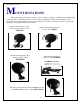
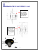

Mount Installation Guide
7
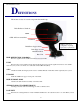
FUNCTION OF ANTENNA MOVEMENT
AZIMUTH
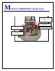
Once the antenna is deployed, the Controller (Indoor Unit) will instruct the mount to rotate clockwise
and then counter clockwise to sweep the sky for satellites. If the system does not see a satellite that it can
identify once it rotates to its clockwise or counter clockwise, as it stops against an azimuth limit it will go up
2 degrees and reverse directions. If it does not see a satellite that it can identify on this pass when it hits the
opposing limit it will go down 4 degrees in elevation. If nothing seen, it will go up 6 degrees, ever widening
its search pattern until it has swept a "box" in the sky. If nothing is found in this search pattern the system
will display an error as to what it thinks is wrong.
SKEW
Once the controller has identified two satellites or has input from a vGPS, it will calculate the arc in
which the satellites reside and tilt the antenna (and LNB's) to align each LNB at the end of the LNB Arm
with their appropriate satellites. If you travel from Southern Florida to Southern California the skew angle
will change dramatically. It will tilt or skew the antenna an opposite or more extreme direction. It will
change somewhere in the middle of the country depending upon the satellites that you are looking for.
DEPLOYED
If the mount has quit moving it has probability acquired, identified and maintained a high signal lock
and you are probably watching TV.
STOWED
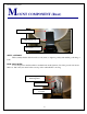
When the mount is given a command to stow, it will elevate fully to clear any object on your roof,
bring skew into a neutral position and then rotate in azimuth until it hits an azimuth limit. At that time it will
move down in elevation until it comes to rest in a travel position. This is an important step. This will
prevent the automatic stow feature that an overpass provides. (just checking to see if you were reading the
manual).
ELEVATION
The controller remembers its last elevation that it saw when it last identified a satellite. It will rise to
that specific elevation to shorten your search time. If the system has a vGPS then that device will provide
the controller with the proper required information for proper satellite acquisition.