
Installation guide

AppendixA / FindingDSSAzimuthandElevations123
The DSS receiver can also use the latitude and longitude of the installation site to
determine the azimuth and elevation to the DSS satellites. There two steps to do
this. The first is to determine the latitude and longitude of the installation site. In
the second step, that site's latitude and longitude are used to determine the azimuth
and elevation to the DSS satellites.
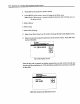
Use the map on page 119 to determine the latitude and longitude of the installation site.
Then connect either the RF output (or video output if you have a monitor type of
television) and use the following procedure:
1. Turn on the TV and DSS receiver.
2. Tune your TV to channel 3 or 4, depending on the setting of the CH3/CH4 switch
on the back of the receiver.
3. Press DSS on the receiver's remote control.
4. Press MENU on the remote control to bring up the Main menu.
Note: Each of the receiver's screens includes instructions that will help you use
the menu system.
5. Select Options.
6. Select Setup.
7. Select Dish Pointing.
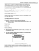
8. Select Point Dish Using Latitude and Longitude to bring up the latitude and
longitude display screen.
,
Enter your latitude and longitude using the number keys on the remote control.
Select OK when you have finished.
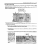
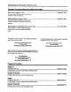
L_itudeandl_itudo
Latitude and Longitude Display Screen
Once the latitude and longitude are entered, the display screen gives you the correct
azimuth and elevation for the installation site. Write both these numbers down so that
you can refer to them later.