
Installation guide


Appendix A / Finding DSS Azimuth and Elevations 121
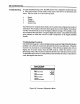
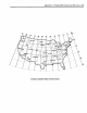
SATELLITE 101_ WEST
LATITUDE
45
45
45
45
45
45
45
45
45
45
45
45
45
5O
50
50
50
50
50
50
50
6O
50
5O
50
50
LONGITUDE
65
7O
75
8O
85
9O
95
100
105
110
115
120
125
66
70
75
80
85
90
95
100
100
105
11S
120
125
*MAG.
DECL.
+20
+18
+13
+8
+3
-1
-5
-10
-13
-16
-17
-18
-18
+23
+21
+16
+7
+5
+1
-4
-9
-14
-17
-20
-21
-22
TRUE NORTH
AZ
226
220
215
209
203
105
188
181
174
167
161
154
148
223
218
212
207
201
194
180
181
175
168
162
156
160
*MAG.
NORTH AZ
246
238
228
217
206
194
183
171
161
151
144
136
130
246
229
228
214
206
195
184
172
161
151
142
135
128
ELEV.
27.2
29.8
32.1
34.1
35.8
37.0
37.8
38.2
36.9
37.4
36.3
34.0
33.0
23.4
25.6
27.6
29.3
30.7
31.8
32.4
32.7
32.6
32.1
31.2
29.9
28.9
*NOTE:THE MEG. DECUNATION VALUES ARE APPROXIMATE SINCE THE
MEG. DECUNATION SHIFTS WESTWARD AT THE RATE OF 1° EVERY 8½
YEARS.
DSS Satellites Location Chart
steps to find determine the azimuth and elevation to the DSS satellites from your
installation site.
Use the following procedure to find the DSS satellites azimuth and elevation with the
installation site Zip Code:
1. Turn on the TV and DSS receiver.
2. Tune your TV to charmel3 or4, depending on the setting of the CH3/CH4 switch
on theback of the receiver.