
Installation guide


118 Appendix A / Finding DSS Azimuth and Elevations
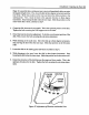
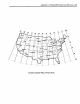
A coarse alignment of the satellite antenna to locate the satellite can be accomplished
by using the following map and charts. The map shows latitude and longitude lines
running through the United States. The additional curved lines on the map represent
the magnetic variation of the earth's magnetic field. The charts show what azimuth
and elevation to use when pointing the dish for a given location. Both the true north
and magnetic north azimuths are provided.
Because the earth' s geographical north pole is not the same as the magnetic north pole,
magnetic north and true north readings are not the same. A compass, being a magnetic
device, will point to magnetic north, not true north. To point the dish in the fight
direction, the magnetic variation must be considered when calculating the azimuth.
The charts show the magnetic variation, true north azimuth and the magnetic north
azimuth. The magnetic north is the reading used when finding the azimuth with a
compass.
To point the dish using the map and chart:
I. Find the approximate location of the installation site on the map.
2. Locate the nearest latitude (horizontal) line.
3. Locate the nearest longitude (vertical) line.
4. Find the row in the chart with the same latitude and longitude as found in steps 3
and 4. Use the magnetic north azimuth and its associated elevation to point the dish
in the fight direction.
For example, if the dish were being installed in Houston, Texas, the latitude would be
approximately 30a and the longitude approximately 95-*W. The magnetic north
azimuth would be approximately 186_ with an elevation of approximately 54.4 _.
Although these values are only approximate, they will get the dish pointed in the
general direction so a fine alignment can be made using the pointing menus in the
receiver.
The DSS receiver also calculates the azimuth and elevation to the DSS satellites from
the installation site. It does this with two methods. Once method, uses the Zip Code
of the installation site while the other method uses the installation site's azimuth and
elevation. Before you can use either of these methods, you must f'trst connect your
satellite receiver to a TV. Once the TV is connected to the receiver, use the following-