
Installation guide

106 Installation/Aligning the Dish
There are four steps to align the dish:
1. Determine the azimuth and elevation settings for your geographic location.
2. Adjust the elevation.
3. Adjust the azimuth.
4. Acquire and fine tune a signal.
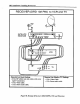
To align the Digital Satellite System, first find the approximate position of the
satellites at the installation site. Then adjust the azimuth and elevation to point the
dish at the satellites. With the receiver connected to both the dish and television, use
the receiver's alignment menus to accurately point the dish at the satellites. This
alignment aid actually uses the errors detected in the received signal to determine
signal quality. Naturally, when there is minimum number of errors in the received
signal, the signal is the strongest and dish is correctly pointed.
Determine the Azimuth and Elevation Settings For Your Location
In this step, you determine the azimuth and elevation setting to point the dish at the
satellites. These settings will vary depending on your location in the continental
United States. There are several methods to determine these settings. The following
is the simplest method (other methods are given in appendix A of this training manual).
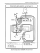
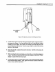
The following method uses the dish positioning menus of the DSS receiver. To use
these menus, connect either the S-video, video, or RF outputs of the DSS receiver to
a television. Apply AC power to the receiver and tune the television to the correct
input (S-video, video, or RF CH3 or 4).
Use the following procedure to get the proper azimuth and elevation:
lo
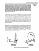
Point and select through the menu system of the satellite receiver to get to the dish
pointing menu. To do this, use either the remote control or the front panel buttons
of the receiver. Once the first level of menus are on the screen, highlight the
"Options" selection to bring up the second level of menus. Select the "Setup"
option of this menu. In the next menu, select "Dish Pointing" to bring up the dish
pointing menu.
2. Once at the dish pointing menu, there are two ways to determine the correct
azimuth and elevation setting for your site. The first of these uses the zip code and
the second uses the latitude and longitude coordinates of the installation site.