
User's Manual Part 2

Operator Manual
2−124
3748DOC020102 Edition: 14.JAN.2005
2.5.1.6 MAP MENU − LOAD −
LOAD
Load allows you to load a saved MAP. This function provides various MAP categories.
The NSC system uses the saved LATITUDE / LONGITUDE co−ordinates to
identify the correlation between the MAP and the sea area currently displayed in
the radar video.
The subsequent MAP lists are then automatically adapted to the changing radar
video view.
LOCAL MAP
Local MAPS are MAPS whose saved co−ordinates match the current sea area.
DISTANT MAP
Distant MAPS are MAPS created for a different sea area.
The MAP names are shown in a list. Toggle fields allow you to scroll through this list.
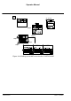
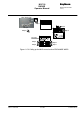
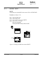
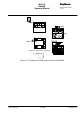
Procedure: (see Figure: 2−73)
Step 1 Open the FUNC menu
Step 2 Open the MAP menu
Step 3 Open the MAP menu function LOAD.
Step 4 Select LOCAL or DISTANT.
Select the desired MAP.
Pressing the LOAD softkey shows the MAP in the radar video. If
necessary, select another range scale to find the LOCAL MAP in the
Radar Video. Possible corrections can be made using the MAP MENU
function CONTROL (see chapter 2.5.1.2).