
User's Manual Part 2


Operator Manual
Raytheon Marine GmbH
Germany
R
NSC 18
RADAR
2−113
3748DOC020102Edition: 14.JAN.2005
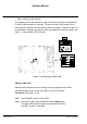
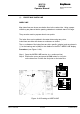
(3) CREATE MAP INDEX LINE
INDEX LINE
Map Index lines are shown as relative lines in the radar video. Using a paper
chart they are planned before passing obstacles to maintain stand−off range.
They are also used to prepare wheel−over points.
The index lines can be plotted in the radar video using two points.
Index lines can either be shown as continuous or dotted.
The co−ordinates of the index lines are ship−specific (relative) and are shown in
(°) for the bearing and in (NM) for the distance in the EDIT INDEX LINE display.
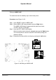
Procedure: (see Figure: 2−66)
Step 1 Open the INDEX LINE function (e.g. continuous line)
Step 2 Position the cursor and press the Left button for 1st point
on the index line. Position the 2nd point on the index line.
Step 2
Figure: 2−66 Creating an INDEX LINE
Step 1