
User's Manual Part 2


Operator Manual
Raytheon Marine GmbH
Germany
R
NSC 18
RADAR
2−109
3748DOC020102Edition: 14.JAN.2005
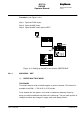
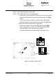
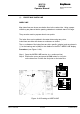
Deleting a TRUE MARK
Procedure: (see Figure: 2−62)
Step 4 Open SELECT mode for TRUE MARK
Step 6 Open DELETE mode for TRUE MARK
Step 2 Select TRUE MARK using trackball and press Right button.
The MARK is deleted immediately.
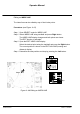
(2) CREATE MAP NAV LINE
NAV LINE
Navigation lines are shown as absolute lines in the radar video.
The navigation lines can be plotted in the radar video using polygons. This
means that the navigation lines can be either continuous or dotted.
The co−ordinates (LAT/LON) of the polygon points can be shown in the display
(EDIT NAV LINE) using the cursor.
NOTE
Navigation Lines are stored by latitude and longitude. Ensure that correct
positioning information is available before creating a new map.
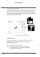
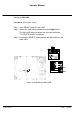
Procedure: (see Figure: 2−63)
Step 1 Open the NAV LINE function (e.g. continuous lines)
Step 2 Position the cursor and press the Left button for the start of the 1st
line. Position the cursor at the next point and press the Left button
again. Repeat this action until the desired NAV LINE is shown in the
radar video.
Pressing the Right button completes the NAV LINE