
User's Manual Part 2

Operator Manual
2−106
3748DOC020102 Edition: 14.JAN.2005
2.5 FUNCTION MENU
This menu provides additional functions.
2.5.1 Select MAP MENU
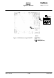
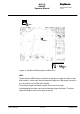
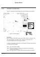
The MAPS function allows the operator to create and permanently store maps.
MAPS are normally produced for the current radar video. For example, they can
be saved under the name of a sea area corresponding to the radar video. If the
ship enters this sea area again, the associated map can be loaded.
A map is formed by adding true mark symbols, nav lines and index lines to the
radar video at points selected by the operator or at areas of interest. The
symbols can be used to mark navigation channels, exclusion or safety zones,
buoys or other pertinent points.
NOTE
Valid position information is required to create maps. Position information
is transferred from a position receiver (e.g. GPS) to the NSC in the form
of data telegrams.
The MAP MENU cannot be called up without valid position information.
A map can be made up of any combination of 100 TRUE MARKS, 50 NAV
LINES and 50 INDEX LINES.
As a map is created, it is placed in temporary storage. It is then saved
(if desired) and placed in permanent storage. The maps may be placed in
permanent storage. Each map may be assigned a label made up of alpha
numeric characters.