
User Manual

Using the QuanumGPS as a Path Logger
Although the description for this product is wrong about recording a path, it is worth buying. It
conveniently records maximum flight speed and path length, which is worth the $50. But to record the
path requires you to spend about $25 more. You will need this:
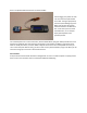
OpenLog from Sparkfun: https://www.sparkfun.com/products/9530
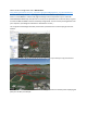
OpenLog is the red thing on the
left. At the top is an R/C receiver
which can be the source of 5V but
otherwise not needed to record
GPS path.
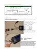
OpenLog is an Atmel 328
microcontroller on a circuit board
that is pre-wired and preloaded
with firmware that will take in the
signal from the QuanumGPS.
Nothing to program and only the
connector between them is
needed to be soldered up. (This is
detailed below).
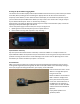
On the back side of the OpenLog is a microSD card reader. (Enough for 320 thousand hours of flight
time, by the way.) Each time you unplug the OpenLog or each time you remove and replace the SD card
the OpenLog closes a file and opens another. When you move the SD card to a reader on your PC at
home, that SD card resembles a hard disk and you just move (or copy) files onto your PC.
This is what the files look like from the OpenLog:
LOG00059.TXT
LOG00060.TXT
LOG00061.TXT
Inside each file is something very readable:
$GPGSV,4,4,14,46,42,148,40,51,49,161,46*7C
$GPGLL,3352.85174,N,11756.45278,W,220116.00,A,D*78
$GPRMC,220117.00,A,3352.85174,N,11756.45282,W,0.045,,191015,,,D*69
$GPVTG,,T,,M,0.045,N,0.084,K,D*2B
$GPGGA,220117.00,3352.85174,N,11756.45282,W,2,12,0.83,69.3,M,-32.7,M,,0000*50
$GPGSA,A,3,46,51,29,15,27,24,18,22,16,21,20,14,1.52,0.83,1.27*0B
$GPGSV,4,1,14,10,38,306,34,14,20,188,29,15,35,053,39,16,18,268,18*79
$GPGSV,4,2,14,18,73,339,46,20,22,055,25,21,68,045,46,22,46,262,42*75
$GPGSV,4,3,14,24,08,109,27,26,13,240,,27,27,315,23,29,24,157,39*7A
$GPGSV,4,4,14,46,42,148,40,51,49,161,47*7D
$GPGLL,3352.85174,N,11756.45282,W,220117.00,A,D*7C
$GPRMC,220118.00,A,3352.85172,N,11756.45283,W,0.086,,191015,,,D*6E
$GPVTG,,T,,M,0.086,N,0.159,K,D*25
$GPGGA,220118.00,3352.85172,N,11756.45283,W,2,12,0.83,69.2,M,-32.7,M,,0000*59
$GPGSA,A,3,46,51,29,15,27,24,18,22,16,21,20,14,1.52,0.83,1.27*0B
This format is called NMEA and each line is a NMEA sentence. Most are redundant. The easiest one to
understand is $GPGGA. You can see N for north latitude and so on. The world of GPS software is huge,
as you can imagine, and much of it is available for the tinkerer. My favorite website for converting the