
User's Guide

18
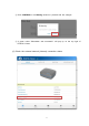
2.4.2 Accuracy
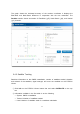
Users can compare a true coordinate with RTAP2U’s high-precision coordinate in
real-time. The comparison is visible through a graph and numerical data on
DEVIATION PLOT in the RTAP2U Viewer.
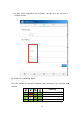
① Click Info on the RTAP2U Viewer bottom bar and select DEVIATION PLOT on
the top bar.
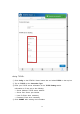
② Choose the Input Type of the Reference Position. Click ENTER and type in the
coordinate needed to calculate the accuracy. Then click SET to apply.
XYZ: ECEF
3)
X, Y, Z coordinate (meter)
LLH: latitude/longitude (degree), height (meter)
③ Instead of manually typing in the coordinates, users can also click CURRENT
POSITION to use the current RTAP2U coordinate for the Reference Position.
④ Click ▶ to start calculating the accuracy in comparison to the Reference Position.
⑤ Click ■ to pause the calculation.
Use the icons below the graph for tracking, zooming in and out, and more.
: Zoom in and out
: Start and pause the comparison recording
: Set the recent comparison point as the center
: Move to the origin of the graph
: Restart the comparison recording
3) ECEF: Earth-Centered Earth-Fixed