
User's Guide
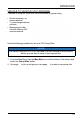
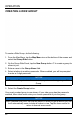
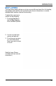

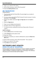
Table Of Contents

MAP LAYERS
The map layers button allows you to turn on and off map items like: hill shading,
topography, and satellite view (available with internet connection on models
equipped with wireless internet functionality).
To adjust the map layers
visible, do the following:
1. From the Map Menu,
tap the Map Layers
q
from available options.
2. A menu of map layer
options will pop-up.
3. From the pop-up menu
you can select what
layers you wish to have
on or off.
Satellite Layer Shown
(available with an internet
connection)
45
OPERATION