
Data Sheet
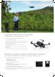

PARROTFIELDS MOBILE APP FOR AGRICULTURE
MAPPING AND SCOUTING MADE QUICK & SIMPLE
1
• Perform fully automatic flights or fly manually over your crops
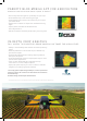
• Generate NDVI maps in real-time during the flight
• Compare NDVI maps to monitor the evolution of your crops on
your mobile device
• Explore areas of interest via unique semi-automated scouting
flights
• Capture photos and videos on-demand with the
ParrotSkycontroller2
• Add text annotations and shoot photos directly from the ground
• Identify in-field variability faster with the new instant processing
engine
• Generate predefined or custom index maps for detailed crop
performance analysis
• Visualize and understand crop trends by comparing different
data layers side by side
• Create comprehensive zonation and prescription maps for more
precise fertilizer applications
• Import or draw field boundaries and annotate the crop
‘focus areas’ for a more in-depth inspection
• Export prescription maps to your tractor or FMIS for seamless
integration into existing agriculture workflows
“Processing speed coupled with great analytics, creates a product that
brings true value to the customers. No other software can achieve this
level of efciency.”
Nicholaus Helwig, Owner Pinpoint Aerial Solutions
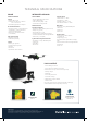
1. Parrot Bluegrass Fields includes a one-year subscription to both the ParrotFields mobile app and Pix4Dfields software (desktop & cloud)
IN-DEPTH CROP ANALYSIS
FULL ACCESS TO PIX4DFIELDS DRONE MAPPING SOFTWARE FOR AGRICULTURE
1
ParrotFields