
User Guide


14
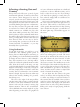
many small villages, hamlets, and towns; how-
ever, in Europa Universalis III, we pay attention
only to the largest and most important city in
each of the provinces. You will see the provin-
cial capital displayed on the map, and its size
will give you an indication of the overall popu-
lation of the region. There will be a flag fly-
ing from each provincial capital to show which
country currently owns it. If you don’t recog-
nise the flag, you can hover your mouse pointer
over the province and a small tool tip will ap-
pear to provide you with those details.
If you have the “decorative map info”
graphics option enabled, you may also see some
small towns and villages on the map. These are
there purely to enhance the overall visual ap-
peal of the game and have no effect on actual
game play. They do help to provide a visual
clue about the total population of a province
-- as does the size of the provincial capital city’s
graphic -- which has a fairly large effect on
the amount of tax income generated for your
country and the amount of manpower that it
will contribute to your armed forces. We will
explain the majority of this when we take an
in-depth look at your provinces.
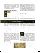
Each country has a national capital that is
of vital importance to the realm. You can eas-
ily see each country’s capital by looking for a
golden crown circling a province’s flag on the
map. Losing control of your national capital
will cause fairly significant damage to your
economic situation, and will result in a loss of
prestige that will impact your ability to con-
duct diplomacy with other realms. Prestige and
the art of diplomacy are covered in the chapters
on domestic affairs and diplomacy.
You may see a variety of other small graph-
ics displayed on the map. Most are used to
show that one of a variety of special “province
improvements” has been constructed in the
province. There will also be a number of loca-
tions that contain a special “bag of gold” sym-
bol to indicate that the province is a regional
center of trade. Provinces that are on a sea or
ocean’s border will often contain a special port
symbol positioned somewhere on the coastline.
This is a quick way to see that it has a port suit-
able for a fleet to make harbour and conduct
repairs. You’ll find each of these described in
their appropriate sections of the manual.
While Europa Universalis III does not mod-
el individual storms or weather patterns, some
provinces are subject to periodic seasonal ef-
fects of winter. This is shown graphically on
the map and has three different levels of effect:
mild, average, and severe. Winter conditions
will greatly increase the attrition rates suffered
by any army that is on campaign outside of its
nation’s borders and should be avoided if at all
possible. Details of this can be found in the
section on the Military.
You will notice that most of the map is
somewhat darkened, except for the provinces
that belong to your country and any immedi-
ately adjacent provinces. This is called the “fog
of war” and it prevents you from seeing any-
thing that isn’t immediately within your gen-
eral area of control. Certain diplomatic actions
will lift the fog of war from a friendly country’s
provinces, but in most cases you will only be
aware of your own lands and of the provinces
located in the vicinity or your armies and fleets.
We’ll discuss this further in the sections on Di-
plomacy and the Military.
Many distant provinces will be completely
obscured by a white, impenetrable fog. These
areas are called “terra incognita” (Latin for “un-
known land”) and will remain hidden from
view until you have explored them or learned
about them from other countries. There are
also some parts of the world that are so remote
and inhospitable that you will never be able to
explore or colonize them. These areas are called