
User's Guide
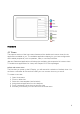


Table Of Contents
- Welcome to the Q Experience 2.0.
- Important information
- Introduction
- 1 Sidebar
- 2 View
- 3 Application
- 4 Home menu
- 5 Map
- 5.1 Map basics
- 5.2 Location properties
- 5.3 Navigation/ Set a destination
- 5.4 Map’s application menu
- Widgets
- 5.5 Chart settings
- Chart orientation
- Heading line
- Show trail
- Autocenter
- Autozoom speed limit
- Low speed zoom level
- Easy view™
- SonarChart™
- 2D shading
- Community edits
- Chart details
- Satellite overlay
- Satellite overlay opacity
- Default zoom level
- Safe water depth
- Shallow water depth
- Spot soundings
- Depth contours
- Minimum fishing range
- Maximum fishing range
- Reset chart settings
- 5.6 Location and route properties
- 6 Dashboard application
- 7 Compact dashboard widget
- 8 Fishfinder
- 9 Radar
- 10 Music
- 11 Weather
- 12 Info
- 13 Settings
- 14 Q Mobile App
- 15 Glossary

20
Map menu (found through the Map’s application menu )
5.4.1 Stop and pause
Stop or pause an active navigation.
5.4.2 Search
The Search function allows you to explore and find places.
5.4.3 Chart settings
Find detailed settings to use for navigation from the
Chart settings
. Read more about chart
settings below in Chapter 5.5
Chart settings
.
5.4.4 My Places
View and manage all your saved places.
Select an existing location to view and manage its position and properties. Select (+)
New
place
to create a new place on your current location – you can adjust the location while
creating a new place, for more accurate positioning.
5.4.5 My Routes
View and manage all your saved routes.