
User's Guide
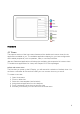


Table Of Contents
- Welcome to the Q Experience 2.0.
- Important information
- Introduction
- 1 Sidebar
- 2 View
- 3 Application
- 4 Home menu
- 5 Map
- 5.1 Map basics
- 5.2 Location properties
- 5.3 Navigation/ Set a destination
- 5.4 Map’s application menu
- Widgets
- 5.5 Chart settings
- Chart orientation
- Heading line
- Show trail
- Autocenter
- Autozoom speed limit
- Low speed zoom level
- Easy view™
- SonarChart™
- 2D shading
- Community edits
- Chart details
- Satellite overlay
- Satellite overlay opacity
- Default zoom level
- Safe water depth
- Shallow water depth
- Spot soundings
- Depth contours
- Minimum fishing range
- Maximum fishing range
- Reset chart settings
- 5.6 Location and route properties
- 6 Dashboard application
- 7 Compact dashboard widget
- 8 Fishfinder
- 9 Radar
- 10 Music
- 11 Weather
- 12 Info
- 13 Settings
- 14 Q Mobile App
- 15 Glossary

15
4.2 Utilities
Under
Utilities
, you will find all the utility applications, like Settings, Weather, and Info. Utility
applications are opened on top of your current view, instead of a dedicated view. Press the
close button (X) in the top right corner, to close the utility application, and return to your main
view. Utility applications consist of a tab list on the left and a content area on the right.
Utility applications cannot be assigned into custom views.
Utilities
5 Map
Here you can navigate, explore, and save places and routes.
Launch the Map view by opening the Home menu and selecting
Map
. The Map application
consists of the Chart area, Application controls in the top right corner and optional Compact
dashboard in the top left corner.