
User's Manual


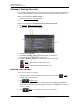


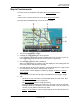

Table Of Contents
- End User License Agreement
- Table of Contents
- Introduction
- Welcome
- Getting Started
- Basic Operations
- Security
- Direct Help
- Selecting Destinations
- Zagat Points of Interest (POIs) (Optional Accessory)
- My Destinations
- Working With Routes
- Working With Maps
- TMC (Traffic Information) (Optional Accessory)
- Integrated Bluetooth (Hands-Free Operation)
- Logbook
- Customizing Your NAVIGON 21MAX
- Legal Notices
- Technical Data
- Index

Working With Routes
Simulating routes
March 2008 NAVIGON 21MAX User’s Guide 61
NAVIGON, INC.
Simulating routes
You can also view a simulation of a calculated route.
Starting a route simulation
You have calculated and displayed a route.
With the route displayed in Map Preview mode:
•Tap Options > Simulation.
The route is recalculated for simulation purposes. Simulation starts when calcula-
tion has finished.
Ending simulation
You can end simulation at any time.
While viewing the route simulation:
•Tap (Back).
A window prompts you to confirm your decision to cancel navigation.
The
ROUTE PLANNING WINDOW redisplays.
Note: GPS signal reception is not required for simulation. Simulations are restricted to
routes of a maximum of 93 miles.